
What happens when you take North America and simmer it in hot water? You produce a record-breaking heat wave! In late June and early July, we broke over 5,000 hot temperature records.
Read Next
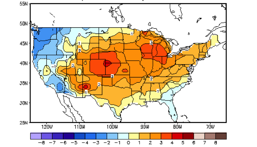
For the last 30 days, US temperatures have been much hotter than usual. (The map is in ˚C, with each degree being 1.8˚F) Source −NOAA
That is what has happened this year. The Gulf Stream and other tropical Atlantic currents have been unusually strong and fast this year. This carried hot tropical water north. (Indeed, some Atlantic fishermen have reported seeing warm water fish arrive four to six weeks early this year.) As a result, North America’s East and Gulf Coasts have seethed with waters that are 1˚ − 3˚C (that’s 1.8˚ − 4.4˚ F) hotter than normal. Prevailing winds have carried the warm marine air inland. As a result, a warm summer has evolved to a broiling summer.
Your local weather person will talk about high and low atmosphere pressure. He or she will explain that there has been a high-pressure area blocking the heat waves so that they can’t sweep out to sea. As a climatologist, I know history. Every time we have the Atlantic this hot, we have blocking and heat waves.
Every time you steam vegetables, you are seeing exactly why the US and Eastern Canada has been so hot this summer.
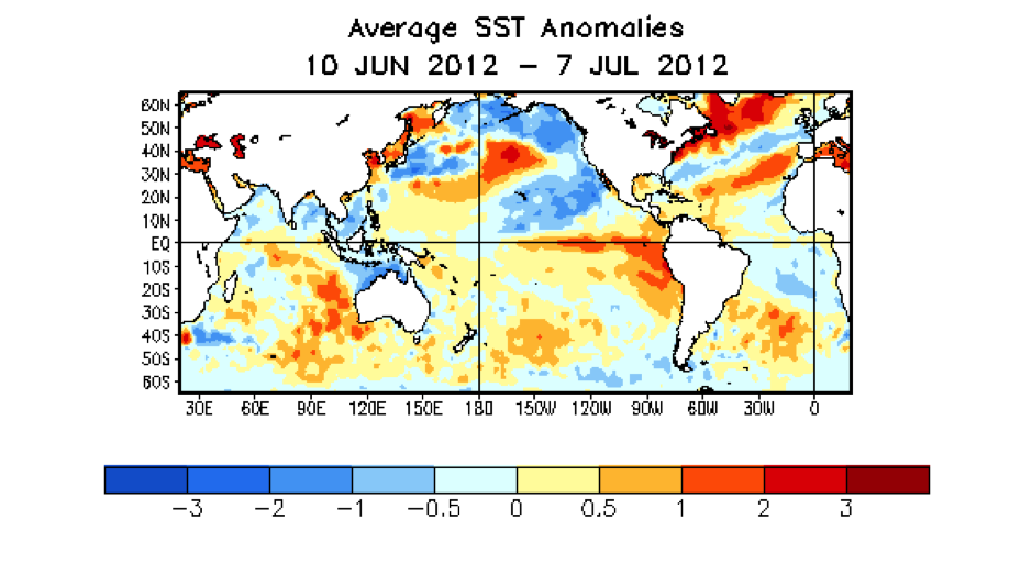
Global water temperatures, compared to normal. Notice the hot water simmering in the Gulf and North Atlantic. Also, notice the developing El Niño. (The map is in ˚C, with each degree being 1.8˚F) Source −NOAA
When you look at the waters off the West Coast, however, you see cool water. Whenever cool air is blown in from the Northwest and it hits the heatwave, it is like a car crash. The collision of cool air and super-hot air produces storms. Just remember the recent “land hurricane” that left millions without power
When you look at the global water temperatures, however, you can see hope in the Pacific.
Do you see all that warm water in the Tropical Pacific? That’s the beginnings of an El Niño. Scientists expect it to become a full El Niño sometime this summer.
The good news is that El Niños typically bring great weather for the US and parts of Canada. In summer, they bring cooler temperatures and more rain to our croplands. In fall, they protect American shores from hurricanes. In winter, they bring warm weather to the north and drought breaking rains to the East.
So as July continues to storm and sizzle, hang in there. El Niño is coming to the rescue.
James J. Garriss


ADVERTISEMENT
Why is there blocking patterns now? We didnt have that last winter, but shouldnt blocking make a cooler summer? Maybe the el nino that is developing has already started to switch our winds
I live in St. Louis, MO. I remember we had a El Niño year 2-3 years ago... But can't remember the weather. What has it historically meant for St. Louis and how long does El Niño last?
Is it possible to tell whether the NAO will go positive, neutral, or negative late summer into fall? or is it still too early? I live in West Virginia and like SOOO many others we also want a cooler wetter fall. I dont wanna have a hard time getting out of summer this year like we did last year. I guess when el nino develops itl do a great job getting us into the fall we all dream of. Not warm and dry like last year. Thats not what we need, i just want "normal" not our fourth warmest winter on record nor coldest. Just average :)
Unfortunately, it isn't. The best forecasts only make estimates for 14 days. You can find them here:
http://www.cpc.ncep.noaa.gov/products/precip/CWlink/pna/nao.mrf.gif
Overall, with the Atlantic as warm as it is, the odds slightly favor a negative NAO.
I hate summertime. I dont know if you feel the same way, but ive been through so many summers and never have enjoyed it. its nothing but heat and humidity!! Who wants to go outside and melt? not me. I like winter. My grandbaby whos 5 loves the snow. You should have heard her ask "when is it going to snow" all the time. I want our winters back and Id hate to say it but I dont even know if well see one again after this sad year. We had nice, cold winters before this year but we might be in for a brutal one. Soak us and cool us down el nino
I'm in total agreement, which is why I live on a mountain in the desert -- low summer humidity and lovely snow for the nearby ski resort.
I don't know where you are located, but I hope the El Nino brings you better weather.
Well this summer is much better for us on the gulf coast of Texas. Last year we spent better part of 3 months above 100 and no rain. But did have our usual humidity unlike the very low humidity they had in the midwest.Thank you God for the nice rains we have been getting this past week.No hurricanes and it will be a perfect summer for Texas.
I wrote a blog about driving through your lovely state last summer. It hurt to see how bad the drought was!
El Ninos usually reduce the odds of hurricanes hitting Texas. Your state has certainly earned the right to a decent summer.
I love winter... I live in Eastern Pennsylvania. Am I to assume that winter, again, will be without snow and cold???????? I hope that isn't the case.
Thanks for your blog!
Normally El Ninos bring Pennsylvania "double dip" winters. It is cool in early and late winter, but warmer than average in mid-winter. Overall, the winter has less snow and cold.