
Did you know that originally weather services said that Hurricane Sandy would die off when it left the Caribbean Sea?
A pattern called the “Greenland High” was creating winds that would shear off the top of the storm. Instead, the extraordinarily hot waters of the Atlantic kept Sandy alive and the shearing winds pushed Sandy straight into New Jersey.
Read Next

The same winds that steered Sandy into the East Coast will be helping to shape the weather in early winter. Source: NOAA
Sandy is gone. The “Greenland High” however will be coming back and helping to shove more wet weather into the East Coast early this winter. No, not hurricanes, winter storms with snow, that white stuff that we didn’t see last winter.
Let’s explain. The hot waters of the Atlantic are still unusually warm off the Northeast coast. They were unusually warm all spring and summer and it will take a while to cool off. This means that when cold continental air hits this hot marine air, you get wet energetic storms. We saw this with Sandy, which was horrendously damaging despite only reaching Category 1 in wind power. It acquired energy from the cold front that was hitting the East at the same time. (See that line of clouds in the satellite picture? That’s the cold front that blended with Sandy to make a hybrid “Frankenstorm.) We will see this wet crash of warm and cold air until the Atlantic finally cools.
Secondly, when you get a hot Atlantic, it creates a weather pattern called a negative North Atlantic Oscillation (NAO). As I have mentioned in previous blogs, the North Atlantic Oscillation acts like a crossing guard. When it is positive, it lets cold storms leave North America and cross the Atlantic. When it is negative, it blocs the storms. The cold fronts remain in North America.
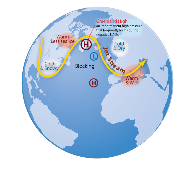
Warm Atlantic waters tend to encourage the development of negative NAOs and blocking Greenland High air pressure. Source: NOAA
This Halloween we had a negative NAO. It blocked Sandy from drifting out into the Atlantic. It created an atmosphere pattern with the Greenland High that turned shearing winds into steering winds and steered Sandy into the East Coast.
History suggests that Negative NAOs are more common when the Atlantic is warm. So expect the same blocks that affected Sandy to affect many of this winter’s storms. They will form Nor’easters and linger on the East Coast. This doesn’t mean that early winter would be astonishingly cold but it will be snowy.
So it looks like you will be able to build some snowmen this winter.
NOTE: I always try to write an upbeat blog. However, it hurts to see the damage that Sandy has done. My best wishes to everyone trying to recover.
James J. Garriss


ADVERTISEMENT
I'm an employee of The Old Farmer's Almanac General Store. While trying to push the new 2014 Almanac, we're constantly asked whether or not the booked predicted Sandy would hit. From what I'd seen, it didn't look like it did. Am I missing something? Thanks for the help!
-Eric
Supervisor at The Old Farmer's Almanac General Store, Bethlehem,PA
Hi, Eric,
You're not missing anything! We did not predict it‚ and neither, it seems, did much of anyone else, including forecasters in the days preceding. Sandy was a unique confluence of events.
--Your OFA editors
Last month in October, we ended the streak of above average warmth and November is bringing something quite the same.. powerful snowstorms moving up the east coast bringing winter blasts then the cold will bite the west (there is alot of snow out west right now) and the east has a mild break. Now im hearing the pattern will reverse itself and biting cold will move away from the west and bother the other folks in the midwest and east coast. Is this the pattern we'll see this winter? Everybody will have their fair share of wintry blasts and snow. I commented on your last blog and asked something about Sandy. Well were all fine! The northeast is doing quite well recovering as well.
The weather patterns between winter and spring have become a month later, with snow towards January and with snow possible late April. There hasn't been a normal pattern for several years. Snow is an insulator around your foundations and rooftops, heating bills are reduced as the drafts from non-snow days are blocked. Hopefully, we will get snow for the economic benefit, just not foot measures of it.
Its been too cold here in the northeast. Im going to get outdoors and enjoy the nice fall days while we have them. When they say 70 degrees in November.. you take it!!! I dont even think itl be this warm again until spring. Ive been hearing many many many times that this winter the cold is indeed coming and winter is 43 days away so we better get some work done, just as a warning in advance when will the -NAO come back? Brrrrrrr..
Should I give up hope on winter now, its supposed to be unusually warm the next 2 weeks in Virginia. Its just such a crime to have cold weather now. I miss winter oh so much. When will the warm weather leave us alone?! I dream of a cold December afternoon with snow glistening in the sunlight, that would actually be my christmas present (I guess that was before 2011)
Actually a cold front is going to move through your area in the mid atlantic and northeast. It will knock down the temperatures into the 50s next week so enjoy one more warm day!!
And theres clues the cold will be back by Thanksgiving. Dont give up on winter. Just like Evelyn said.. this winter will be much much colder than last. This pattern we're in now is favoring colder weather and storms on the east coast. Odds are, you will get your December afternoon you dream of :) Have a GREAT holiday season and enjoy your winter that is officially less than 6 weeks away
sources: http://www.cpc.ncep.noaa.gov/products/precip/CWlink/pna/nao_index_mrf.shtml
You see that the -NAO is setting up (thats good news for you) My uncle used to be a weatherman and I know quite a bit about the weather myself
How about the Northwest part of the country? West of The Cascades? We haven't had a good cold snap for a few years! We need a good cold winter to control all the bugs! Also, I Love the snow!
On NOAAs long range temperature predictons they're calling for above normal temperatures all the way up until November 21!! (the farthest we can see) Is this gonna be yet ANOTHER unusually warm Thanksgiving and holiday season? I want the cold to come back to the lower midwest and east coast soon. I too agree the holiday season last year was ruined by spring-like warmth
Does this mean it will reach as far as Southwestern Ontario Canada again also?