
Hurricane Ian hitting Florida on September 28, 2022.
NOAA and CSU Hurricane Forecast Summaries
Get out your raincoat! With record-warm sea surface temperatures, experts predict above-average activity, with the highest numbers that NOAA has forecasted to date. If the destructive Category 1 Hurricane Beryl and Hurricane Debby are any indication, we are in for a wild ride. See the hurricane forecast, including how many storms are expected to make landfall. Plus, we answer your questions about Earth’s most powerful storms.
When is Hurricane Season?
The Atlantic hurricane season officially starts on June 1 and ends on November 30, though hurricanes can occur outside of the season. (In the Northeast Pacific, the season starts earlier, on 15 May.) The forecasts below cover the Atlantic Basin, encompassing the Atlantic Ocean, Caribbean Sea, and Gulf of Mexico.
Many indicators related to atmospheric and oceanic conditions indicate what to expect when it comes to hurricanes. Whatever the forecast, remember that it only takes one hurricane to make landfall, and coastal residents should prepare for every hurricane season.
Read Next
Hurricane Forecasts 2024
In The 2025 Old Farmer’s Almanac, our long-range weather predictions for the year highlight when hurricanes are more likely to be active in different regions; we don’t, however, issue specific hurricane forecasts. Therefore, we have provided easy-to-read summaries by the foremost hurricane experts at NOAA and Colorado State University (CSU) with links to their full reports.
In 2024, NOAA and CSU predict an above-average Atlantic hurricane season; however, abnormally warm sea surface temperatures counteracting the coming La Niña make for a challenging forecast. Learn more:
2024 NOAA Hurricane Prediction
On May 23, NOAA’s Climate Prediction Center released its outlook for the 2024 hurricane season in the Atlantic as “above-normal hurricane activity.” Specifically, NOAA predicts an 85% chance of an above-normal season, a 10% chance of a near-normal season, and a 5% chance of a below-normal season.
This prediction is based on the following factors, all of which tend to favor tropical storm formation:
- Near-record warm ocean temperatures in the Atlantic Ocean
- Development of La Nina conditions in the Pacific
- Reduced Atlantic trade winds
- Less wind shear
NOAA is forecasting a total of 17 to 25 total named storms (winds of 39 mph or higher). Of those, 8 to 13 could become hurricanes (winds of 74 mph or higher), including 5 to 7 major hurricanes (category 3, 4 or 5; with winds of 111 mph or higher). This is the highest forecast that NOAA has released to date. NOAA has a 70% confidence in these ranges.

(Image credit: NOAA)
CSU 2024 Hurricane Prediction
On August 6, the CSU experts updated their forecast to above-average hurricane activity, stating, “We anticipate that the 2024 Atlantic basin hurricane season will be extremely active.” CSU predicts 23 named storms during the Atlantic hurricane season. Of those, the CSU update forecasts that 12 of these could become hurricanes, and 6 may reach major hurricane status.
The forecast reflects these main factors:
- El Niño is expected to transition to La Niña conditions. This will bring with it hurricane-favorable wind shear conditions and record warm sea surface temperatures.
- A warmer Atlantic increases the likelihood of an above-average hurricane season as hurricanes thrive on warm ocean water and lower atmospheric pressure, creating a more unstable atmosphere that favors hurricane formation.
The other big question is whether the hurricanes will hit Florida and other coastal areas. The probability of U.S. major hurricane landfall is estimated to be above average. As is the case with all hurricane seasons, coastal residents are reminded that it only takes one hurricane to make landfall, which makes it an active season for them. They should prepare the same for every season, regardless of how much activity is predicted.

Last Season’s (2023) Hurricane Forecast
In total, the 2023 Atlantic hurricane season produced 20 named storms, with winds of 63 kmh (39 mph) or greater, of which 7 became hurricanes, with winds of 119 kmh (74 mph) or greater. Three intensified to major hurricanes – Idalia, Ophelia, and Lee - with winds of more than 178 kmh (111 mph), according to the end-of-season tally from the US National Oceanic and Atmospheric Administration (NOAA).
An average Atlantic hurricane season has 14 named storms, seven hurricanes, and three major hurricanes. The 2023 season was the fourth most active season on record. But it takes just one landfalling storm to wreck communities and economies. The 2023 Atlantic seasonal activity fell within the NOAA’s predictions for named storms and hurricanes.
What Are the 2024 Hurricane Names?
See the list of 2024 hurricane names for both the Atlantic Basin and Eastern North-Pacific. The World Meteorological Organization’s Hurricane Committee chooses these names. The list actually repeats every six years unless a storm is so severe that the World Meteorological Organization votes to retire that name from future lists.
Many hurricane names have been retired since 1950 because they resulted in significant property damage or deaths. A name can be retired at the request of a country affected by the storm. See the most recent list of retired hurricane names.

Facts About Hurricanes
Q. What Is a Hurricane?
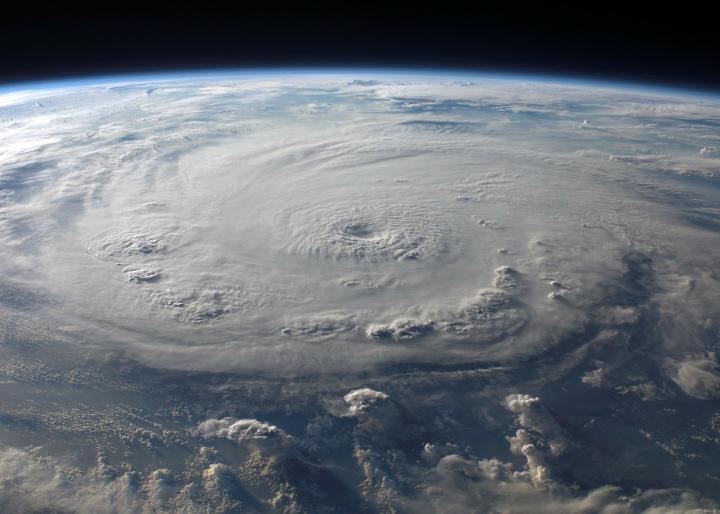
A. A hurricane is a tropical storm with winds that have reached a constant speed of at least 74 mph in the North Atlantic Ocean, Caribbean Sea, or Gulf of Mexico. A hurricane’s winds blow in a large spiral around a relatively calm center of extremely low pressure known as the eye of the storm. Around the rim of the eye, winds may gust to more than 200 mph. The eye of a storm is usually 20 to 30 miles wide and may extend over 400 miles. The entire storm can be up to 340 miles in diameter, dominating the ocean surface and lower atmosphere for thousands of square miles.
Q. How Does a Hurricane Form?
A. Hurricanes only form over warm waters in the tropics (usually above 27°C, o. r about 81°F). Think of a hurricane like a giant engine. Its fuel is warm, moist air—which rises from the oceans, causing an area of lower pressure below. Then the air from surrounding areas with higher air pressure pushes into the low-pressure area. Then that “new” air becomes warm and moist and rises, too. As the warm air continues to rise, the surrounding air swirls in to take its place. As the warmed, moist air rises and cools off, the water in the air forms clouds. The whole system of clouds and wind spins and grows, fed by the ocean’s heat and water evaporating from the surface. Around their core, winds grow with great velocity, generating violent seas. Moving ashore, they sweep the ocean inward while spawning tornadoes and producing torrential rain and floods.
Storms that form north of the equator spin counterclockwise. Storms south of the equator spin clockwise. This difference is because of Earth’s rotation on its axis.
Q. How Do We Know a Hurricane Is Coming?
A. Unlike tornadoes or other weather events, no hurricane goes unnoticed, thanks to satellite technology. So, pay attention to hurricane warnings!
- A hurricane watch means that hurricane-force winds are possible within 48 hours.
- A hurricane warning means that hurricane-force winds are likely within 36 hours.
See our article on “Predicting Hurricanes: The Eyes Have It” to learn more.
It usually takes several days to a week for a tropical storm to grow into a hurricane, and there is often plenty of time to take precautionary measures unlike some extreme weather events (such as a tornado).
But if conditions are just right, a powerful major hurricane can develop in just hours. This has been called “rapid intensification” by the National Hurricane Center. When conditions are just perfect, a storm can increase its wind speed 35 mph in 24 hours or less—about two categories on the Saffir-Simpson scale, which grades hurricane strength from 1 to 5. Rapid intensification, however, is rare, with just one or two Atlantic storms per year undergoing such an acceleration.
Q. What Is the Cause of Hurricane Damage?
A. Hurricanes actually weaken when they hit land, because they are no longer being “fed” by the energy from the warm ocean waters. When hurricanes move over large landmasses, they can die out quickly because they lose the power of the heat and condensation. However, they often move far inland, dumping many inches of rain and causing lots of wind damage before they die out completely. So it’s not just high winds that cause danger; it’s the torrential rains and storm surges. A hurricane can last for 2 weeks or more over open water and can follow a path across the entire length of the eastern seaboard, coastal areas, and barrier islands.
Q. Which Areas Are Most Susceptible to Hurricanes?
A. All Atlantic and Gulf coastal areas are subject to hurricanes or tropical storms. Although rarely struck by hurricanes, parts of the Southwest and Pacific Coast suffer heavy rains and floods each year from the remnants of hurricanes spawned off Mexico. Islands such as Hawaii, Guam, American Samoa, and Puerto Rico also are subject to hurricanes.
Q. What is a Hurricane Vs. a Tropical Storm?
A. A hurricane is actually one of three kinds of tropical storms, or cyclones, that circulate over tropical waters. The circulation is counterclockwise in the Northern Hemisphere. Tropical cyclones are classified as follows:
- Tropical Depression: An organized system of clouds and thunderstorms with a defined circulation and maximum sustained winds of 38 mph (33 knots) or less.
- Tropical Storm: An organized system of strong thunderstorms with a defined circulation and maximum sustained winds of 39 to 73 mph (34 to 63 knots).
- Hurricane: An intense tropical weather system with a well-defined circulation and maximum sustained winds of 74 mph (64 knots) or higher. In the western Pacific, hurricanes are called typhoons. Similar storms in the Indian Ocean are called cyclones. Hurricanes are further classified by rank according to how strong their winds are.
Q. How Are Hurricanes Classified, and What Are Hurricane Categories?
A. The Saffir-Simpson Hurricane Scale is a 1 to 5 rating based on the hurricane’s present intensity. This is used to give an estimate of the potential property damage and flooding expected along the coast from a hurricane landfall. Wind speed is the determining factor in the scale, as storm surge values are highly dependent on the slope of the continental shelf in the landfall region. Wind speeds are measured using a 1-minute average.
| Saffir-Simpson | Wind (mph) | Hurricane Examples |
|---|---|---|
| Category One | 74 - 95 | Allison (1995), Danny (1997) |
| Category Two | 96 - 110 | Bonnie (1998), George (1998), Gustav (2002) |
| Category Three | 111 - 130 | Roxane (1995), Fran (1996), Rita (2005) |
| Category Four | 131 - 155 | Opal (1995), Iniki (1992), Charley (2004), Katrina (2005) |
| Category Five | 156 + | Andrew (1992), Matthew (2016), Irma (2017), Maria (2017) |
For Almanac long-range weather predictions, find 60-day forecasts on the Website or find 12 months in the annual Old Farmer’s Almanac.
Catherine Boeckmann


ADVERTISEMENT
Isn’t this 2024?
Survived Hurricane Andrew--Cat 5 in Miami Dade August 1992--total devastation..
all we are just dust in the wind...@ 11 years young thought nothing could scare me...6pm halloween eve...light drizzle...9pm heave rain with heavy wind...midnight wind slamming from the east taking out all grandma's fruits and vegs plants in the yard...3am ground floor flooding had to evacuate to upstairs...6am four walls upstairs pancaked...we were soaked for hours...9am rescued to neighbours home...KKKAT 5...175MPH...GUSTS 225MPH...13FT FLOODS...NOW @ 70 YEARS...HAVE NOT SEEN THE LIKES EXCEPT EARTHQUAKES...
Yeah I agree with the other writer. Your math doesnt add up. maybe you are thinking of Camile or Bertha. Both serious storms. I went thru Andrew. When the eye passed over New Orleans we all went down to the local tavern and shared storied until the rain started again. pretty bad storm. I also sat thru Ivan in Niceville Fla in 04. He was a bombastic storm centering his path of destruction right thru Nicevile and Destin and Ft Walton Beach. He was followed by Dennis the following July at which time I moved over back over to New Orleans, got settled and lost everything to Katrina. It happens. In south central Fla now waiting to see what happens this year.
Pretty interesting “story” since hurricane Andrew’s eye didn’t pass through NOLA but, through central Louisiana where I was.
Hello James,
Nice post, but your your math doesn't work.
You say you were 11 years old during Hurricane Andrew -- which occurred in 1992, (30 years ago).
That would make you 41 today. Yet you say you are 70 years now.
Either you are making this all up, or you are remembering a different storm?
Been through 6 of them here in Port Saint Lucie..they were all Cat3. They were horrifying to say the least. Some were short and some were relentless. All you can think of when is it going to pass. The stress is unbearable. The fear is strong. Going to sleep is impossible.
Home owner in Florida, did notice during a active hurricane season hornets and wasps would nests on east side of house, is this a common occurrence that you know of? Was really amazing when Charlie came through in 04 there were hundreders!
Interesting about the wasps. I am paying more attention this year to the hurricane season as I am booked to go to Cancun September 18, 2023. First vacation since 2011. Hoping I don’t have to use the travel insurance I bought. As someone who grew up in a house that flooded every 5 to 7 years in Houston Texas, floods, tropical storms and hurricanes are part of my life. Someone else on here said they lived someplace and hurricane hit then they moved somewhere else and another storm hit so they moved back to Louisiana and then came Hurricane Katrina ; lost everything. I can relate. It sucks. I was living along the gulf coast in Mississippi when Hurricane Katrina came, and my life was forever altered. Nothing has been the same since. I never did recover financially, and at my age now, I doubt I ever will. That storm ruined my marriage, negatively affected my life and to this day I have problems with work because of it. I’m not military, so no PTSD diagnosis for me. If people think these storms hit and hit hard, and then the area and the people recover, they are sadly mistaken. The area might recover, but not all of the people do.
PTSD is not just for military. I was told this by a therapist.