
All About Nor’easters Storms
Utter the word Nor’easter, and you’re sure to turn some heads. Nor’easters are synonymous with snow, wind, rain, coastal flooding, and blizzard-like conditions. Let’s discuss why these storms happen and what makes them potentially so dangerous.
What is a Nor’easter?
A Nor’easter, short for “Northeaster,” is a deep area of low pressure that wreaks havoc on the northeastern U.S. a couple of times a year.
Nor’easters get their name from their prominent wind direction—from the northeast! Nor’easters tend to be very wet because the center of the low pressure is over the ocean or along the coast, causing those on land to feel strong northeasterly winds and whatever precipitation comes with them, rain or snow.
Read Next
Nor’Easters can occur at any time of the year but are best known to cause major disruptions between September and April. These “winter” storms bring snow, flooding rains, strong winds, and rough seas to New England.
These storms usually develop in lower mid-latitudes between 30 and 40° N (think GA to NJ) and within 100 miles east or west of the coastline. Their movement is generally northward to northeastward along the coast and typically attain maximum intensity near New England and the Maritime Provinces.
Note: Nor’easters can turn into blizzards if they bring high winds and other blizzard conditions. See what defines a blizzard.
Famous Nor’easters
Many folks in New England can name the year (and often the month and day!) that a nor’easter impacted their life.
Part of why nor’easters are so fascinating and damaging is they often impact the populated I-95 stretch from Washington, D.C., to Boston, including Philadelphia and New York City. These areas are home to about 60 million people.
Some well-known historical nor’easters include:
- Blizzard of 1888
- Ash Wednesday storm of March 1962
- New England Blizzard of February 1978
- March 1993 “Superstorm” or “Storm of the Century”
- Blizzard of 1996 (a personal favorite of mine)
- As well as recent storms in 2015, 2016, and 2018.
Past nor’easters have been responsible for substantial disruption, including closed highways, school and business closures, loss of power, and flooding. Damage from the worst nor’easters can exceed a billion dollars, according to the National Weather Service.
What Causes a Nor’easter?
There is a reason these storms only occur in the northeastern U.S. Between September and April, the jet stream moves cold and dry air from the Arctic south across the plains of the U.S. and Canada and east toward New England and the Maritime Provinces.
In the northeastern U.S., this cold air clashes with warm air heading north from the Gulf of Mexico and the Atlantic Ocean. This collision of cold and warm air then moves over the “warm” ocean water, thanks to the Atlantic current called the Gulf Stream. As cold air passes over the warm water, it warms, rises, and condenses. This temperature difference is the fuel that feeds nor’easters. As cool air pours over the warm ocean, you have constant rising motion, creating an area of low pressure and fueling it, and you will often see the pressure continue to drop for the duration of the storm.
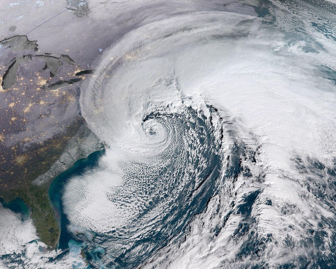
On a satellite image, nor’easters can often look like hurricanes, but they operate very differently. Think of it like a gas versus diesel vehicle. A nor’easter thrives on the differences between the cold air from the land and the warm air over the ocean. Let’s call this our diesel engine. A hurricane survives on purely warm ocean waters to create constant rising motion, which we can call a gasoline engine. If you put diesel in your gasoline engine, or vice versa, it’s not going to work. The same concept applies here. While both “engines” are deep areas of low pressure, how they work and are fueled is very different.
Why So Much Snow and Rain?
A nor’easter brings substantial precipitation with it, thanks to the warm water of the Gulf Stream that helps bring more water vapor, which cools and condenses as it rises in low pressure. But why do they bring so much snow and not just rain?
Let me share an interesting tidbit. All precipitation in the United States starts as snow, regardless of the time of year. What happens in the layers of the atmosphere below the clouds and near the ground determines whether you get rain or snow (or sleet or freezing rain).
In a nor’easter, cold air is usually abundant on the western and, specifically, northwestern sides of the storm. This allows the precipitation to start and end as snow. As you get closer to the center of that low and especially as you move south and east of it, you’re in a part of the storm that is pulling up warmer air from the south, and it almost always changes to rain around or south and east of the center of that low.
As meteorologists forecast who will see snow or rain, we look at where the center of that low will pass. If it passes over the New England coastline, you’ll see more rain along and around I-95. If, however, the low passes 100 miles out to sea, this brings snow to a wider area.
Nor’easters can bring several inches of rain with them. The amount of water present in snow is about 1 inch of water for every 10 inches of snow, but this varies greatly. Those really wet, heavy, cement-like snows can have a ratio of as little as 1:6, whereas light and fluffy snows have more of a 1:20 ratio. If we do the math, and a nor’easter is forecast to bring 2 inches of rain, that can be 2 feet of snow if the cold air is there to support it.
Moreover, the deep area of low pressure combined with the cold and moisture can often produce snowfall rates of 1-3 inches per hour or greater. When you add gusty winds (that form from pressure differences; the deeper the low, the stronger the wind), you can have blizzard-like conditions throughout the northwest quadrant of a nor’easter, limiting visibility for hours at a time.
Coastal Impacts
While they are very different storms, a nor’easter can have hurricane-like effects on coastal areas. While northern and western parts of the storm receive snow, southern and eastern zones can receive several inches of rain in a very short period of time. This can lead to many kinds of flooding:
- Urban flooding (poor drainage due to infrastructure)
- Fluvial flood (a lake or river going over its banks)
- Pluvial flood (something is now under water that wasn’t before)
- Coastal flood (like storm surge, where the ocean moves further inland than usual)
Often, these rains fall on ground that can’t hold much more water, which means the ground is near supersaturation, and the water can’t be absorbed so it flows to a lower elevation. Ground can also be frozen near coastal areas if winter has been cold enough, preventing water absorption.
This added water to the system flows toward coastal areas, which may be further inland than average due to the wind and surge from a nor’easter. This causes devastating flooding along the entire New England coast.
Stay safe! See how to prepare for a Nor-easter storm or a blizzard.
Cyrena Arnold


