
Hancock County Iowa (Latitude 42°56’21” N Longitude 93°52’24” W), July, 2017.
Ever wonder about all of those right angles?
Ever looked down from an airplane over the Midwest and noticed all the right angles? Many towns were planned in squares. And does the squaring of the Midwest extend to the idea of being the land of the square deal—solid and reliable? Find out why the Midwest is square.
Me seemes the world is runne quite out of square, From the first point of its appointed sourse, And being once amisse, growes daily wourse and wourse.
–Edmund Spenser, from The Fairie Queene
Even though our house is a conventional, solid brick structure that any bank would be glad to make a loan on, it makes my fellow Midwesterners nervous. It doesn’t set “square with the world.” Not to set square with the world is an affront to the senses in the corn belt flatlands, a callow lack of social grace, indicating probable tendencies toward secular humanism and other terminal diseases.
Read Next
People who do not build houses facing precisely east and west, or north and south, can hardly be trusted to be fair and square in their dealings. Worse, they might allow pictures on the wall to hang crooked. Had the Leaning Tower of Pisa been built in northern Ohio, it would long ago have been razed to preserve the rectilinear sanity of our society.
A house sitting at an angle to the compass’s directions disturbs the Midwestern mind’s delicate equilibrium. At a party in our house, the conservation will soon drift from matters of national concern to important news like who broke the window in the old Mifflin schoolhouse or the new paint job on Uncle Al’s barn. Since such points of interest would be almost visible out our windows in daylight, the person talking will invariably nod or point in the direction of the subject under discussion - a habit of country folk who always know exactly where they stand in relation to everyone and everything in our area. Once a direction is indicated, however, the conversation veers off into an argument:
“You talking about Al’s barn?”
“That’s what I said, ain’t it?”
“Well, you’re pointing more towards Carl’s. Al’s is a tad more easterly.”
“You’re both wrong. The way you’re pointing, there’s nothing but cornstalks all the way to Harpster.”
“Well, now, just where do you think East is? This house doesn’t set straight, you know.” (Frowns all around.)
“Oh, that’s right. It’s the corners that point the directions.”
“Not quite.” (I am talking now, trying to, haha, set matters straight.) “The corners actually point a bit off direction, too.” No one seems to think that’s as funny as I do.
Soon, people are up, pacing nervously, peering out into the dark, trying to fix their location from the mercury vapor pole lights on the horizon. The house has turned into a spacecraft, yawing off into the universe without a compass or a gyroscope. The walls do not indicate up-north or down-south. If Uncle Al’s barn is not where it is supposed to be, what can you believe these days? They straighten lopsided pictures on my walls. They find excuses to go home early.
The Country of Squaredom
I live in the country of Squaredom that begins here in north central Ohio and runs west, at least to the Great Plains. This is the land of the square deal. Plaid shirts are always in style; paisley never. The giant Ralston Purina Company understands the land that nurtures it. Its insignia is the checkerboard square; it calls the Midwest “checkerboard country.”
The new passive-solar houses do not catch on here, not just because the sun rarely shines from November until April, but because the shapes of these structures are rhombic and trapezoidal rather than rectilinear. You couldn’t depend on them. Not solid, reliable, square. The world is divided into the competent who have “everything squared away” and all those idiots “running in circles.”
There is a street in Tiffin, Ohio, called Circular because it actually runs in a semi-circle around the east side of town. When northern Ohioans hear about it, they drive over and cruise this eighth wonder of the world in awe.
A farmer in Wyandot County, Ohio (so help me), insists that at the end of a harvest day in the field, his drivers park tractors, harvesters, and trucks square with the world and precisely parallel to each other. Doesn’t matter whether east, west, north, or south, but by heaven, all shall be the same, or the worker is sent back to correct his mistake. Neatness is a primary virtue.
A crooked dead furrow is more to be lamented than a crooked banker. Another farmer—a good friend, I must confess—feels compelled to keep the corners of his hay field exactly 90 degrees as he mows. Instead of sashaying around the turn, as I do so that I can finish before next Tuesday, he mows through the corner, stops, backs slowly and carefully until the mower blade comes square to the standing hay, and proceeds ahead again.
A neighbor spent thousands of dollars to move a creek that meandered evilly through his land, so that they could “square off” a field. Midwesterners have studded their land with right-angle corners; they think the earth is square, not round.
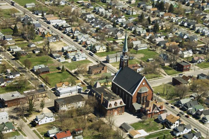 Photo credit: Thinkstock
Why the Midwest is Square
Credit (or blame, depending upon one’s view) for the squaring of the Midwest is often given to Thomas Hutchins, the first Geographer of the United States. Due partially to his influence, Congress, in 1785, two years before the Northwest Ordinance opened the Midwest to settlement, passed a law that stipulated the new lands would be surveyed in a grid pattern of six-mile squares, each square (or township) to be further subdivided into 36 one-mile squares (sections) of 640 acres each.
Surveying the first tract for the Ohio Company of Massachusetts, Hutchins struck his Jacob’s staff on the north bank of the Ohio, square on the Pennsylvania border, and ran a line due west 42 miles to mark off the first seven ranges of townships from the Pennsylvania border. Thus began the pattern of land survey that was to persist throughout the rest of the country except for West Virginia, Tennessee, Kentucky, Maine, Vermont, and Texas (and of course, the 13 original states, which were mostly already surveyed).
In the years immediately following, there would be some experimentation with five-mile squares and, in one case, no squares or system at all, but by the time surveying had been completed in the Delaware Tract, wherein sits my catawampus house with its lopsided pictures, the six-mile square township of 36 sections, the 16th always reserved to finance a school, had become a permanent feature.
Henry Howe, the historian, called the system “one of the great American inventions.” Whether that was true or not, it did provide a way to locate precisely any piece of land within a tract to be surveyed. Thus Rufus Putnam and Manasseh Cutler, leaders of the Ohio Company and the real brains behind Hutchin’s surveying, could sit comfortably in Mr. Brackett’s Tavern, or, more often, in Cromwells’s Head Tavern in Boston, and speak with great geographical lucidity about their land. If Hutchins said that the northwest quarter of section 12 in Township 3, Range 6 (counting ranges over from the Pennsylvania Line and townships from Hutchin’s first baseline survey) was a good place for a city someday and best not to sell it off too quick, everybody knew exactly whereof he spoke.
Unfortunately, playing checkers on a map does not tell one much about the real country involved, and only later would the Ohio Company realize they had bought the poorest, most raged up-and-down land in the state. Many had argued, to no avail, that “the squares would cut indiscriminately across streams, valleys, and ridges in undesirable and awkward ways.” No matter.
If your square straddled a hogback and your neighbor’s covered all the good bottom land below, tough. If your square missed a good supply of water by 20 feet, leaving you forever at the mercy of your neighbor, kismet. If Section 16 fell upon an undrainable swamp, well, let the schools worry about that later. No longer would land parcels be described as was this gerrymandered property in southern Hardin County, Ohio (a small chunk of the Midwest once controlled by Virginia and settled in the “old” style): “Proceed from the large granite rock at the creek to three white oaks growing from one root, thence S 345, E 133 poles to two barren oaks, thence…to a hickory and black oak growing together…to a crooked sugar tree…to a sharp bend in the creek and thence back to the place of the beginning.”
“It is still hell down there,” says a real estate broker from plaid Wyandot County who must venture into the southern paisley half of Hardin County occasionally. “You can’t find anything. People never know exactly where their boundaries are and don’t seem to care. A farm has a number. That’s all. No range, township, and section. Just a damn long number. There’s an old story told about that area that literally came true for me. I asked a man how to get to a certain farm. He scratched his head, thought a while, and said: “You gotta go back to Kenton and start over. You can’t get there from here.”
Who’s to Blame?
Actually, the surveyors are not to blame for the squaring of the Midwest. It was the road builders who really did it. A survey line is only a mark on a map, not visible on the land, like a river or three oak trees growing from one root. In hill country, delineations of property fence or roadway by necessity follow the lines of least resistance, the result more paisley thank plaid, no matter what the survey system. But when the checkerboard squares reached flat northwestern Ohio and on into the flatter land of Indiana and Illinois, then it became possible to mark them physically on the land. The roads were built on the section lines, and every section line had have a road—all the way to Dubuque.
But why not? If the towns were all squares surrounded by streets, why not the country? Cleveland, Zanesville, and other towns, even before they were platted, were set aside as one-mile squares. Platting started with the public square, then little squares or blocks pushed out in all directions until they ran blindly into a river or lake where they appeared to be sloughed off by the water, and the remnants floated away. Circleville, Ohio, is no different, despite its name. It should be called Squareville, like the rest. Its name derives from the circular prehistoric Indian earthworks upon which it is built, a gift from a less unbending civilization.
Don’t Get Lost
City squares transferred to the country on a larger scale produce quintessential boredom for the traveler, but at least it is impossible to get lost. If you head west from my place on a township road and stick to it, you will still be heading west long past Indiana. If you count the perpendicular roads you pass, you know how many miles you have gone.
Count the seconds between roads, and you know how fast you are going. You can do it from a 747, and I have. If the road you are on does end, as at a river, for example, you just take a right angle and go till you find another east-west road that does cross the river.
There are no surprises, unless you fall asleep, an ever-present danger.

Unfortunately, you can’t lay down a straight line on a curved surface for very far unless you dig a terrifically deep ditch. You can’t apply a square piece of paper to an orange of equal plane surface, or vice versa; you can’t accurately transfer a globe to a flat surface. Furthermore, a magnetic compass will not keep to a consistently straight line over a great distance. It will vary differently in different areas and at different times.
Not a Perfect Square
For both these reasons, Squaredom is not nearly as accurate as the square mind would like it to be. Very few 640-acre sections of land actually contain 640 acres. They contain a few more or sometimes a few less. These extra acres, from trying to make a square board fit a curved surface, may be added on to all the quarters of a section, or they may, as in Illinois, all be thrown into the northwest quarter, so that at least three-fourths of the land possesses pure and undefiled rectitude.
Also, you must pay attention when driving straight and narrow township roads. Without warning, they will occasionally veer 15 or more feet to the side before continuing on straight. These are also corrections to make up for the awkward fit of flat square to round globe, or sometimes for the errors of the magnetic compass. You can get a good grasp of the whys and wherefores of these distortions if you study the meridian lines of the globe. They start at a fixed point, the North Pole, and widen as they proceed to the equator and then narrow as they converge on the South Pole. They are thus not straight lines, nor are they parallel, as we are led to assume in Squaredom. One reason Midwesterners love football is that the gridiron is one world in our experience where, by golly, the lines really are straight, parallel, and rectilinear.
Another kind of inaccuracy is inherent in the rectitude of forcing imperfect earth into perfect geometric squares that truly gladdens the hearts of paisley-loving hill folk. Deeply undulating terrain contains considerably more surface acreage than flat terrain of the same survey dimensions. If a giant hand could press down a hill farm flat, it would stick out considerably beyond its boundaries than a flatter farm would. Surprisingly, natives of Squaredom/Flatdom will resent this fact almost militantly, insisting only that “as far as records go, this difference is simply not considered.” It is annoying to the squared mind to realize there are unnumbered acres out there, unbought and untaxed.
What a lovely thought, though, for us whose dead furrows are always crooked, our mowed corners obtuse, our pictures lopsided, and our houses not square with the world.
Gene Logsdon


ADVERTISEMENT
This is fascinating to me about the midwest. Helps to understand a little about the value systems of people from this region of the US. I have some relatives from IL and IA. I don't know them very well, but what I did notice about them is their ideas about fairness --fair and square. Not complicated.
I love this article! I'm from Iowa and never knew any of this. It's true for most of us that we always know directionally where we are.
I loved this. Living in Illinois, in squareville, on a paisley farm bordered by a creek, I'm the oddball and I love it
Would love to know who wrote this -- all the references to Ohio from Wyandot county to Tiffin to Hardin county . . . I'm from west-central (Auglaize county), but spent 20+ years in those areas . . .
Spell checker got you! You refer to your house as a "structure that nay bank would be glad to make a loan on" where surely you meant ANY bank. Totally changes the meaning of the phrase!