
The Bermuda High steers hurricanes.
The Bermuda High—it is as mysterious as the Bermuda Triangle.
In summer, it can steer tropical heat into the eastern and southern US. During the Atlantic Hurricane Season, it determines whether a tropical storm visits a Florida political convention or goes for the gumbo near New Orleans. It shapes American weather and, unfortunately, it can be very unpredictable.
Look at the blank area in the satellite picture of the stormy Atlantic. That’s the Bermuda High. It is an area of high atmospheric pressure that drifts through the Atlantic. It is one of several high-pressure areas around 30˚N.
Read Next
- The air from storms near the equator rises very high and eventually falls back down to earth around 30°North and 30°South.
- This sinking air pushes against the surface creating a high-pressure zone in the atmosphere.
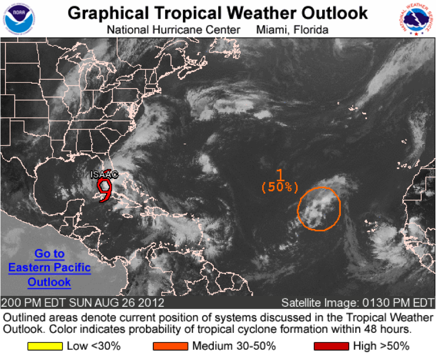
Click to expand image. Credit: National Hurricane Center.
- The winds spin around this high area in a clockwise fashion. (Notice the clouds circling the High.) Storms caught up in these winds are steered to different areas. They stay away from the high pressure.
Think of a high-pressure area as a pinball machine flipper. As the flipper spins around, it steers the pinball. The winds around the Bermuda High steer tropical cyclones towards the west and then northwest. If the high is further out in the Atlantic, the odds are that the cyclones will curve and go out to sea. If the high is further west, there is a good chance that the cyclones can impact the East or Gulf Coasts of the United States.
The problem is the Bermuda High moves. We still are not good at predicting exactly where it will be and how fast it will move. Last week it shifted west and a bit south of its normal position. (It was in the same place as it was in 2004, when Florida got hit by so many hurricanes!) It steered Isaac through the Caribbean islands and up toward Florida.
.png)
Last week the high shifted south and west and began steering Isaac towards Florida. Credit: NASA/Goddard Space Flight Center Conceptual Images Lab
Whoops! The Bermuda High shifted east, just far enough away that it no longer controlled Isaac. Isaac turned, kept going north and never turned northeast. Meteorologists watched a front plunge south, but it was too slow to affect the tropical storm. As I write this, Isaac is sailing north heading toward the Mississippi coast.
The Bermuda High shapes our weather, steering heat and storms into the US and Canada. Unfortunately, its movements are still unpredictable, in their own way as mysterious as the Bermuda Triangle.
James J. Garriss


ADVERTISEMENT
How can I track where the Bermuda High is at any point in time? You indicate on this webpage that we can look at satellite pictures, but is there a website that then outlines it (spoon feeds it to) us? Thanks!
yes that does help and i had to do a report on this for school i thank you every much and it gives me much more research to do on this subject i live in kentucky so i never really had to worry about
I think its great how everybody in this country can all come together and help eachother in terms of extreme weather. For the hurricanes that struck the gulf, well everybody could understand. Money and financial aid has been sent to the states that were hit by Isaac or any hurricane. We all have our fair share of extreme weather. Back in June when we had that terrible windstorm we were helped out. We were declared state of emergency because of the damage, lack of power and extreme heat. No matter what happens.. whether its a tornado, hurricane, blizzard, or any weather disaster; were all here for eachother. I like to think of it that way. This summer has been so hot that we could ALL have some type of empathy. I think everybody has had extreme heat at some point this summer. I mean were not alone becuase we have all 50 states there with us!
what was the worst hurricane of all time and how if you dont mind me asking
Hi, Johnny, It depends on how you define worst: costliest, deadliest, or most extreme? According to NOAA, between 1851 and 2010: "Hurricane Katrina of 2005 was responsible for at least $108 billion of property damage and is by far the costliest hurricane to ever strike the United States. In terms of human deaths, the Galveston Hurricane of 1900 was responsible for at least 8000 deaths and remains first on that list. In terms of extreme weather, Hurricane Katrina had the third lowest pressure ever noted at landfall, behind the 1935 Florida Keys hurricane and Hurricane Camille in 1969." Hope this helps. --The OFA Editors
Please keep the hurricanes out to sea. Either the atlantic needs to calm down or they need to keep their distance away. They cause nothing but severe damage and are very expensive. We need to get to the time of year where we can get the rains WITHOUT the severe storms and hurricanes. What we need is a cooler fall with soaking rains to chip off the drought one step at a time. What would really help is a cold snowy winter to benefit us, the very low snowpack influenced our drought in the Ohio Valley last winter. The snows would soak the ground and create ground moisture suitable for precipitation.. just face it, last years warm winter didnt help us one bit. Of course, some may not like the cold but the snow and precipitation is what its going to take to break the drought. Everybody in AMERICA has suffered through this cruel summer. No hurricanes... just some relief would be our wishes. All of us deserve a winter at this point. I keep hoping things will turn around and things are getting better right now.. slowly though! well all i can say is that we made it. Fall will be here by the end of this month and I couldnt be more than happier, even though it was 90 degrees today but nothing unusual for September because summer isnt over quite yet. Were going back to normal (but I hear its still summer in Texas) lol! but some autumn air is coming, we'll live
is it el nino thats making the east, midwest and south central regions of the US pleasantly cooler and wetter? I have noticed that the hot weather is pretty much gone and thats making me think we will enter fall without the records. Were going in the right direction to breaking our rainfall deficit and I've noticed changes since mid August BUT i dont understand why the tropics arent slowing down at all. This is more active than last year i believe!
Yes, some of that cooler weather is due to the beginning of El Nino conditions, even though it is too early to officially announce an El Nino event.
As for the increased activity in the Atlantic, blame the hot Atlantic and a small climate factor, called the Madden Julian Oscillation. Right now, a MJO pulse has spent the last two weeks creating good wind conditions for storm development in the middle of the Atlantic.
I have 2 weather questions
1. I remember back in 1963 (i believe) 1963-1965 one of those... anyway, I was about 5 years old when Camille made her way all the way up the United States then turned east into the mid atlantic. Everything was flooded and we had to leave our house. We had more than a foot of rain and a couple of people died in Amherst County, VA. I was little, so i didnt know the differnce but why didnt Camille weaken as she made landfall in the south?
2. Just one of those el nino questions you always get. When is el nino coming? Looking foward to some active storm tracks in the autumn! Thank you Evelyn, i just LOVE your blogs! I like to check the weather category very often to see what you've posted. I just like weather. Im no weather expert but i find interst in it
Actually, Camille did weaken. However, it was Category 5, so it still a very rainy tropical depression when it reached VA. Once it neared the coast, it sucked in warmth and moisture from Hurricane Debbie to the southeast. It grew back into a tropical storm. It was "Zombie" Camille that drenched you.
Actually we have El Nino conditions in the Pacific right now, but it has to last a few weeks before it officially becomes an El Nino.